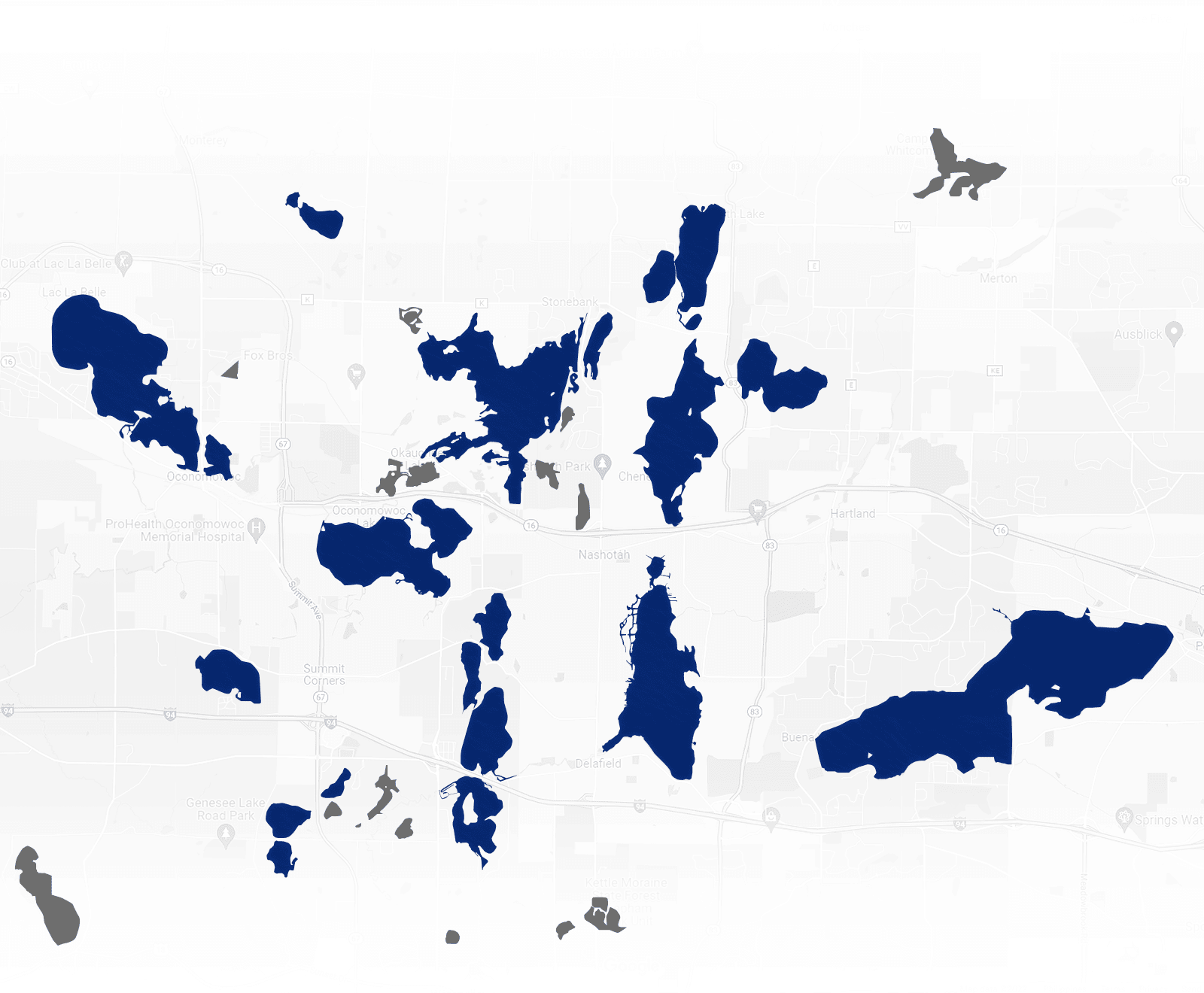
Welcome to the Lake Country Area in the northern part of Waukesha County in Southeast Wisconsin! Located just a short 1.5 – 2 hour drive from the Chicago Area and conveniently nestled between Milwaukee and Madison, you will never be too far from anything! More than 26 lakes play an integral part in the life of the residents in 10 different communities – Oconomowoc, Lac La Belle, Summit, Okauchee, Chenequa, Nashotah, Merton, Hartland, Delafield and Pewaukee. The character of each of these lakes ranges from small “north woods feel” to large “recreational fun.” And, you don’t even have to live ON the lakes to enjoy them! The residents in this area share an affinity with nature that provides recreational activities year-round! The sense of community is strengthened by events such as art festivals, lakefront music festivals, street dances, block parties, outdoor markets and beer gardens. Residents enjoy strong economy, excellent health care facilities, school systems consistently exceeding expectations, churches, convenient shopping for everyday needs and specialty/artisan items, and an abundance of dining choices.

The Lakes of Lake Country
Explore the map below for more

Ashippun Lake

Beaver Lake

Fowler Lake

Genesee,
Lower

Genesee,
Middle

Genesee,
Upper

Lac La Belle

Moose
Lake

Nagawicka
Lake

Nashotah,
Lower

Nashotah,
Upper

Nemahbin,
Lower

Nemahbin,
Upper

North Lake

Oconomowoc Lake

Oconomowoc,
Upper

Okauchee Lake

Pewaukee Lake

Pine Lake

Silver Lake

Lake Keesus
Tamarack Lake
Crystal Lake
Garvin Lake
Grass Lake
Forest Lake
Duck
Lake
Crooked Lake
Egg
Lake
Bowron
Lake
Golden Lake
Utica Lake
Henrietta Lake
Waterville Lake
Ashippun Lake
Community: Town of Oconomowoc
Size: 94 acres
Max Depth: 35 feet
Ave Depth: 22 feet
Clarity: Moderate
Bottom Type: 10% sand, 30% gravel, 0%, rock, 60% muck
Lake Type: Spring
Fish: Panfish (Common), Largemouth Bass (Present), Northern Pike (Present), Walleye (Present)
Public Launch: Yes; Ramp, Concrete Panel Launch Surface
Beaver Lake
Community: Town of Merton, Village of Chenequa
Size: 313 acres
Max Depth: 46 feet
Ave Depth: 15 feet
Clarity: Very
Bottom Type: 60% sand, 0% gravel, 5% rock, 35% muck
Lake Type: Spring
Fish: Panfish (Common), Largemouth Bass (Present), Northern Pike (Present)
Public Launch: Yes; Carry-in , Unimproved Launch Surface
Fowler Lake
Community: Oconomowoc
Size: 97 acres
Max Depth: 50 feet
Ave Depth:
Clarity: Very
Bottom Type: 5% sand, 15% gravel, 10% rock, 70% muck
Lake Type: Drainage
Fish: Panfish (Abundant), Largemouth Bass (Common), Northern Pike (Present), Walleye (Present)
Public Launch: Yes; Ramp, Concrete Panel Launch Surface
Genesee, Lower
Community: Village of Summit
Size: 63 acres
Max Depth: 45 feet
Ave Depth:
Clarity: Moderate
Bottom Type: 0% sand, 20% gravel, 0% rock, 80% muck
Lake Type: Drainage
Fish: Panfish (Present), Largemouth Bass (Present), Northern Pike (Present)
Public Launch: No
Genesee, Middle
Community: Village of Summit
Size: 98 acres
Max Depth: 40 feet
Ave Depth: 8 feet
Clarity: Very
Bottom Type: 30% sand, 50% gravel, 0% rock, 20% muck
Lake Type: Seepage
Fish: Panfish (Abundant), Largemouth Bass (Common), Northern Pike (Present)
Public Launch: Yes; Ramp, Gravel Launch Surface
Genesee, Upper
Community: Village of Summit
Size: 32 acres
Max Depth: 27 feet
Ave Depth: 14 feet
Clarity: Moderate
Bottom Type: 40% sand, 15% gravel, 0% rock, 45% muck
Lake Type: Spring
Fish: Panfish (Present), Largemouth Bass (Present), Northern Pike (Present)
Public Launch: Yes; Carry-in , Unimproved Launch Surface
Lac La Belle
Community: Village of Lac La Belle, City of Oconomowoc
Size: 1154 acres
Max Depth: 45 feet
Ave Depth: 11 feet
Clarity: Moderate
Bottom Type: 10% sand, 80% gravel, 0% rock, 5% muck
Lake Type: Drainage
Fish: Panfish (Common), Largemouth Bass (Common), Smallmouth Bass (Common), Northern Pike (Present), Walleye (Present)
Public Launch: Yes; Ramp, Concrete Launch Surface
Moose Lake
Community: Town of Merton
Size: 83 acres
Max Depth: 61 feet
Ave Depth: 40 feet
Clarity: Very
Bottom Type: 25% sand, 25% gravel, 0% rock, 50% muck
Lake Type: Seepage
Fish: Panfish (Common), Largemouth Bass (Common), Northern Pike (Present)
Public Launch: Yes; Ramp, Concrete Panel Launch Surface
Nagawicka Lake
Community: City of Delafield, Village of Nashotah
Size: 981 acres
Max Depth: 90 feet
Ave Depth: 36 feet
Clarity: Moderate
Bottom Type: 0% sand, 60% gravel, 0% rock, 40% muck
Lake Type: Drainage
Fish: Largemouth Bass (Common), Panfish (Present), Smallmouth Bass (Present), Northern Pike (Present), Walleye (Present)
Public Launch: Yes; Ramp, Concrete Plank Launch Surface
Nashotah, Lower
Community: Village of Summit
Size: 93 acres
Max Depth: 43 feet
Ave Depth: 20 feet
Clarity: Very
Bottom Type: 10% sand, 40% gravel, 0% rock, 50% muck
Lake Type: Spring
Fish: Panfish (Common), Largemouth Bass (Common), Northern Pike (Common), Smallmouth Bass (Present), Trout (Present), Walleye (Present)
Public Launch: Yes
Nashotah, Upper
Community: City of Delafield, Village of Summit
Size: 131 acres
Max Depth: 53 feet
Ave Depth:
Clarity: Moderate
Bottom Type: 25% sand, 45% gravel, 0% rock, 30% muck
Lake Type: Spring
Fish: Panfish (Common), Largemouth Bass (Common), Northern Pike (Present), Walleye (Present)
Public Launch: No
Nemahbin, Lower
Community: Village of Summit
Size: 239 acres
Max Depth: 36 feet
Ave Depth:
Clarity: Moderate
Bottom Type: 10% sand, 30% gravel, 0% rock, 60% muck
Lake Type: Drainage
Fish: Largemouth Bass (Common), Panfish (Present), Smallmouth Bass (Present), Northern Pike (Present), Walleye (Present)
Public Launch: Yes; Ramp, Gravel Launch Surface
Nemahbin, Upper
Community: Village of Summit
Size: 277 acres
Max Depth: 60 feet
Ave Depth:
Clarity: Moderate
Bottom Type: 5% sand, 10% gravel, 0% rock, 85% muck
Lake Type: Drainage
Fish: Panfish (Common), Largemouth Bass (Common), Northern Pike (Common), Smallmouth Bass (Present), Walleye (Present)
Public Launch: Yes; Ramp, Concrete Panel Launch Surface
North Lake
Community: Town of Merton, Village of Chenequa
Size: 440 acres
Max Depth: 78 feet
Ave Depth:
Clarity: Low
Bottom Type: 50% sand, 30% gravel, 0% rock, 20% muck
Lake Type: Drainage
Fish: Panfish (Common), Largemouth Bass (Common), Smallmouth Bass (Common), Northern Pike (Common), Walleye (Present)
Public Launch: No; In Progress
Oconomowoc Lake
Community: Village of Oconomowoc Lake
Size: 818 acres
Max Depth: 60 feet
Ave Depth: 32 feet
Clarity: Very
Bottom Type: 10% sand, 80% gravel, 0% rock, 10% muck
Lake Type: Drainage
Fish: Largemouth Bass (Common), Northern Pike (Common), Panfish (Present), Smallmouth Bass (Present), Walleye (Present)
Public Launch: No; Can access from Upper Oconomowoc Lake
Oconomowoc, Upper
Community: Town of Oconomowoc
Size: 35 acres
Max Depth: 11 feet
Ave Depth:
Clarity: Low
Bottom Type: 60% sand, 10% gravel, 0% rock, 30% muck
Lake Type: Drainage
Fish: Panfish (Common), Largemouth Bass (Present), Northern Pike (Present)
Public Launch: Yes; Ramp, Concrete Plank Launch Surface
Pewaukee Lake
Community: Town of Delafield, City of Pewaukee, Village of Pewaukee
Size: 2437 acres
Max Depth: 45 feet
Ave Depth: 15 feet
Clarity: Moderate
Bottom Type: 20% sand, 25% gravel, 0% rock, 55% muck
Lake Type: Drainage
Fish: Musky (Common), Panfish (Common), Largemouth Bass (Common), Northern Pike (Common), Walleye (Present)
Public Launch: Yes; (3); All 3 are Ramp, Concrete Launch Surface
Pine Lake
Community: Village of Chenequa
Size: 711 acres
Max Depth: 85 feet
Ave Depth: 39 feet
Clarity: Very
Bottom Type: 5% sand, 90% gravel, 0% rock, 5% muck
Lake Type: Spring
Fish: Largemouth Bass (Common), Smallmouth Bass (Common), Panfish (Present), Northern Pike (Present), Walleye (Present)
Public Launch: Yes; Ramp, Concrete Panel Launch Surface
Silver Lake
Community: Village of Summit, City of Oconomowoc
Size: 217 acres
Max Depth: 40 feet
Ave Depth:
Clarity: Very
Bottom Type: 50% sand, 5% gravel, 5% rock, 40% muck
Lake Type: Seepage
Fish: Panfish (Common), Largemouth Bass (Common), Northern Pike (Present)
Public Launch: Yes; Ramp, Concrete Panel Launch Surface
Okauchee Lake
Community: Town of Merton, Town of Oconomowoc
Size: 1210 acres
Max Depth: 90 feet
Ave Depth:
Clarity: Moderate
Bottom Type: 35% sand, 25% gravel, 5% rock, 35% muck
Lake Type: Drainage
Fish: Musky (Common), Largemouth Bass (Common), Northern Pike (Common), Panfish (Present), Smallmouth Bass (Present), Walleye (Present)
Public Launch: Yes; (2); 1)-Ramp, Concrete Panels Launch Surface; 2)-From Golden Mast
Lake Country Wisconsin has long been a sought-after vacation spot for affluent families, nature lovers, and young professionals looking to unwind from the bustling city life. With its laidback atmosphere amid serene lakes and stunning views, the area attracts residents who want to enjoy a luxurious, leisurely lifestyle while being only minutes from the city.
A property at Lake Country will always be good investment. When it comes to value for money, Lake Country homes are unparalleled, thanks to the amazing lifestyle and high quality workmanship they offer.